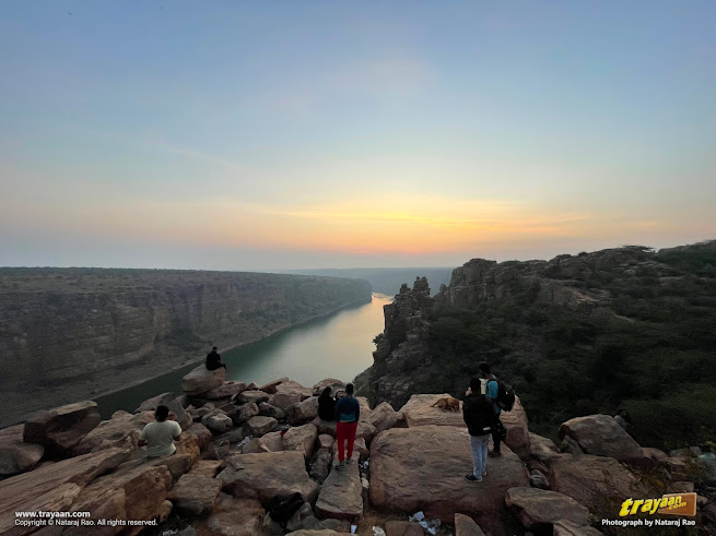
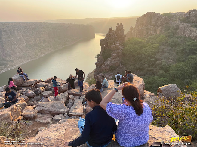
Exploring Gandikota's natural grandeur and its grand heritage, in Andhra Pradesh, India.
Embarking on a journey filled with historical wonders, spiritual enlightenment, and breathtaking landscapes is a traveller’s dream. My recent escapade, in Andhra Pradesh, took me from the mystical depths of Belum Caves to the awe-inspiring natural beauty of Gandikota, which is often called as the "Grand Canyon of India."
Join me as I recount the enchanting moments of this unforgettable expedition, which also uncovered lesser known gems like the remnants of Vijayanagara era temples - Shri Madhavaraya Temple and Shri Raghunatha Swamy Temple, amidst the rich tapestry of Gandikota's tourist attractions.
A time-lapse Video of sunrise at Gandikota
Video
This is the second part of my recent travels which covered Belum Caves and the gorgeous Gandikota.
About Gandikota
Gandikota is located on the southern banks of River Pennar. Its name comes from the Telugu words ‘Gandi’ meaning Gorge and, ‘Kota’ meaning fort. So, it is sometimes also called ‘Gorge Fort’.
Gandikota is around 16 kilometres from Jammalamadugu in the YSR District (formerly named as Kadapa District) of Andhra Pradesh, in India.
A brief history of Gandikota
Gandikota is an ancient historical stone fort built above a hill along the banks of Pennar river, with additions and changes made to it over centuries. It has a huge entrance which is around 20 feet high and has 101 bastions, each of which are over 40 feet in height.
This Fort with enclosed buildings and remnants and Shri Madhavaperumal temple, are heritage monuments protected by the Archaeological Survey of India (ASI).
This fort existed since 1123 CE as per Gandikota Kaifiyat, and there are records of further additions to the fort made in the 13th century CE. A French gem merchant and traveller named Jean-Baptiste Tavernier, who visited it in the 17th century, was so impressed that he said that it was like a second Hampi, the glorious capital city of Vijayanagara.[1][2][3] Hampi - Vijayanagara is now a famed World Heritage Site
Gillela Chalapathi Razu had built a fort at Gandikota, which is around 25 miles east of Tadipatri. He was deputed by Bukka Raya to control Tadipatri region.[4] Bukka Raya (meaning King Bukka) is one of Vijayanagara's co-founders (Hakka and Bukka), reigned from 1356 to 1377 CE).
It was the headquarters of the region during Vijayanagara empire and later it became a prominent fortress which was invaded and besieged several times over the centuries. The Pemmasani chiefs of Gandikota are said to have submitted to the invading Sulthan of Golkonda, and as a result this region was fully under Muslim control by 1650 CE. Mir Jumla, the Golconda General, was in Gandikota on August 27, 1652. But just 33 years later in 1685, Golkonda was annexed by the Mughals and this region and its temples suffered a terrible time under them.[4]
Gandikota has a long history through centuries. It came into prominence during the Kakatiya rule and their subordinate Kayasthas. Over the centuries, it was ruled by many dynasties or kingdoms, including the Kalyani Chalukya, Kakatiya, Karnata Samrajya (Vijayanagara Empire), Qutb Shahi Dynasty, Mughal Empire, Mayana Nawabs, Kingdom of Mysore, and finally, the British in 1791. Historical accounts of ancient conflicts in this area often contain the name of Gandikota. [3]
The fort of Gandikota, has heritage monuments which are worth visiting. Shri Ranganatha Swamy Temple and Shri Madhava Raya temples, which were built during 15th and 16th centuries respectively, beautifully sculpted in the Vijayanagara era temple architectural style. Several 16th century inscriptions from the Vijayanagara period have been discovered at Gandikota.[5] Shri Madhava raya temple is also known as Shri Madhava perumal temple.
There are historical paintings of Gandikota in the British Library, made by Sir Thomas Anbure in 1799 and by Lieutenant Thomas Fraser, in around 1802, during the British rule.
Gandikota's natural heritage
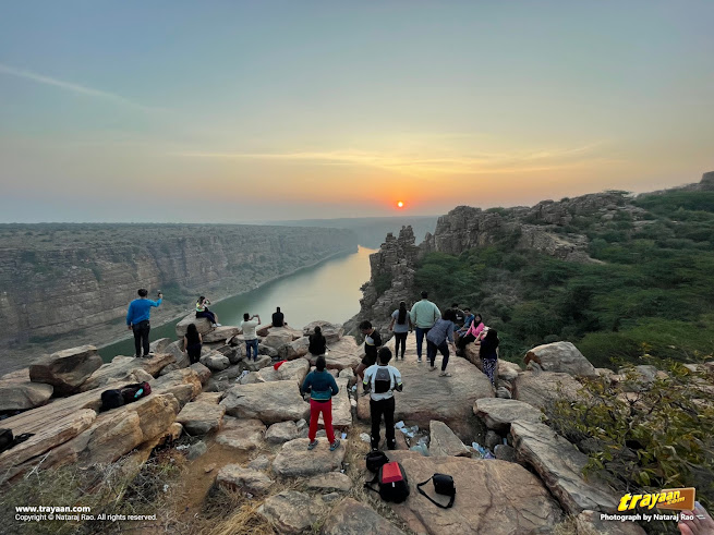
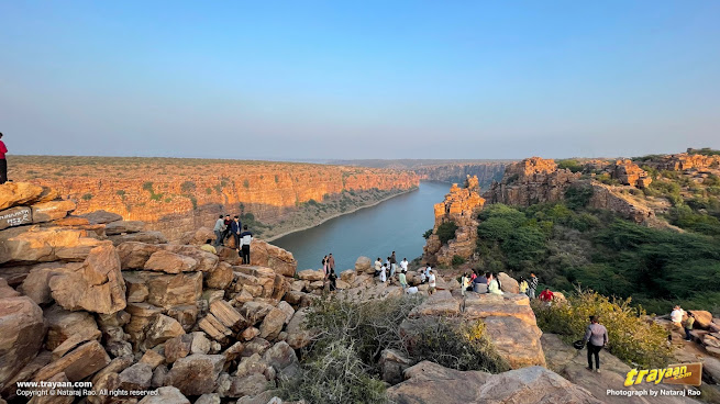
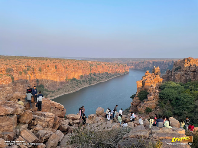
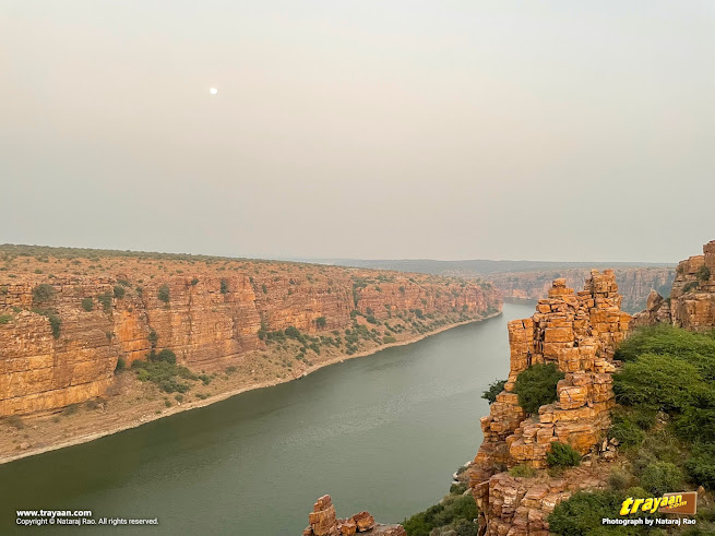
Gandikota is a very important natural heritage site with the Pennar river flowing in the spectacular canyon or a gorge through the Erramala Hills, which offers stupendously splendid views of this great "Grand Canyon of India".
Canyons and gorges are formed by the natural phenomenon of flowing water eroding the rocks or sediments gradually over many centuries.
Gandikota canyon is made of sedimentary rocks, which are named as 'Gandikota Quartzite' in the Chitravati Group, which is a part of Cuddapah Supergroup which is one of the series of thick sedimentary sequences in Indian subcontinent which was formed somewhere around 2,500 to 540 million years ago (the Proterozoic eon).[6]
In the late Proterozoic times, Cuddapah basin (now in South India) was very close to Napier Complex, Enderby Land (now in East Antarctica), during the time of Gondwana or Gondwanaland supercontinenet around more than 160 million years ago! [7]
The Chitravati Group consists of three formations, which are the Pulivendla Quartzite, the Tadpatri Formation, and the Gandikota Quartzite.
The Gandikota Quartzite consists of a lower 40 – 45 metres thick shale – siltstone – quartzite intercalated unit and an upper 140 -190 metres thick quartzite unit.[6]
Quartzite is a metamorphic rock on earth, which is formed when quartz-rich sandstone or chert (a sedimentary rock consisting almost entirely of silica) is exposed to high temperatures and pressures.
The name quartzite implies a high degree of hardness and high quartz content typically up to 90% and in some cases up to 99%. Quartzites are the largest and purest concentrations of silica in the Earth's crust.[8]
Shale is a soft, brittle, fine-grained, and easily eroded sedimentary rock which was formed from mineral-rich silt or mud, which was deposited in the waters, got buried by other sediment and later got compacted into the form of hard rock. When its surface is exposed by erosion, it weathers into thin layers called plates.[9]
Exploring Gandikota
Day 1: Travel to Gandikota and exploring it
Our Gandikota journey began in the afternoon from the mesmerising Belum Caves, the second largest natural caves in the Indian subcontinent. After exploring this natural underground wonder, we set off on a road trip towards Gandikota, marking my route to ensure a smooth and picturesque drive.
Upon reaching Gandikota, I checked into the comfortable Haritha Resorts, a welcoming abode amidst the ancient landscape. The cosy cottage provided a comfortable retreat, preparing me for an evening of exploration.
Gandikota Fort and Monuments
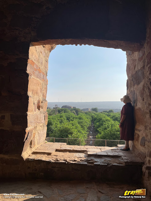
Evening Exploration: Following local guidance, I visited the Gandikota Fort, which has Shri Madhavaraya Swamy Temple, immersing myself in its historical significance and architectural marvels. The journey then led me to the nearby Raghunatha Swamy Temple, a grand heritage temple site that added another layer of spiritual richness to my journey.
Shri Madhavaraya Temple
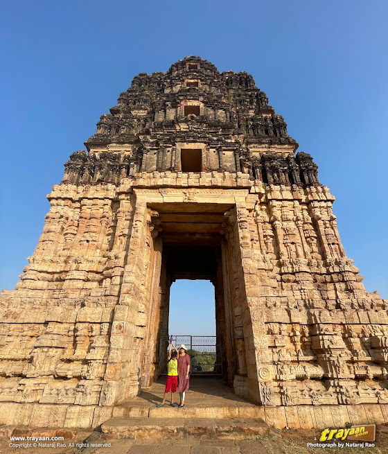
A large and grand four-storey entrance tower (gopura) stands before Shri Madhavaraya Temple in Gandikota, also known as Shri Madhavaperumal temple.
Built in 16th century CE,[5] contemporary to the reign of Shri Krishnadevaraya in Vijayanagara , this grand temple's main gopura measures 16.20 metres X 10.72 metres at the base. The shala-shikhara part above the gopura was unfortunately ruined at some point and doesn't exist anymore.
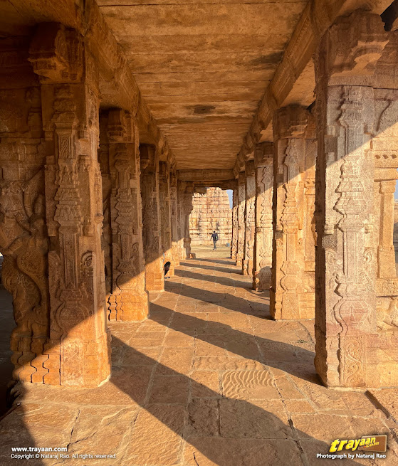
This temple will certainly remind you of Hampi or Vijayanagara, when you look at its beautifully carved columns with three-dimensional riders on rearing Yalis and other figures. This temple is not very large and stands amidst a spacious courtyard surrounded by cloistered corridors. Remnants of brick and plaster parapets are seen above the temple.

This was a temple dedicated to the Hindu God Shri Krishna. Madhava Raya literally means King Krishna. Madhava is one of the names used to refer to Shri Krishna.
Shri Raghunatha Swamy Temple
Shri Raghunatha Swamy Temple is another Vijayanagara era temple. This one stands north of the granary and Jama Masjid. This east facing temple is said to have been built by Pemmasani chiefs. This temple complex is a courtyard of rectangular shape, which is surrounded by walls.
Built by King Kaka Raja in the 16th century[10], it is a beautiful and enchanting temple complex despite being partially ruined. It has may beautifully sculpted pillars and hall, which will also remind you of the glorious temples and remnants of Hampi. Inside the temple, the main statue of the deity in the garbhagruha or sanctum is missing.
Despite this, the temple still provides a beautiful and spiritual feeling, just like the other temple here. The pillars here have splendid sculptured depictions of the Dashavatara (the ten incarnations of Hindu God Shri Vishnu).
There is no entrance tower or gopura over the entrance for this temple complex, and we don't know whether there was one before, which may have been destroyed or collapsed later on.
Jumma Masjid and other significant monuments in the fort
In other monuments within the fort area, a large Mosque complex called Jumma Masjid (also called Jama Masjid or Jamia Mosque, etc.) stands next to a large granary which was used to stockpile food in the event of a siege. This granary has been renovated and is now being used as an office for the authorities managing the fort.
A small ruined pushkarni or a pond with ghats called Kathula Koneru is there near the Jumma Masjid. Kathula Koneru means the pond of swords in Telugu, named so as it said that soldiers used to clean their swords in it after the battles. This pond looks just like a temple pond which is found beside many temples across India.
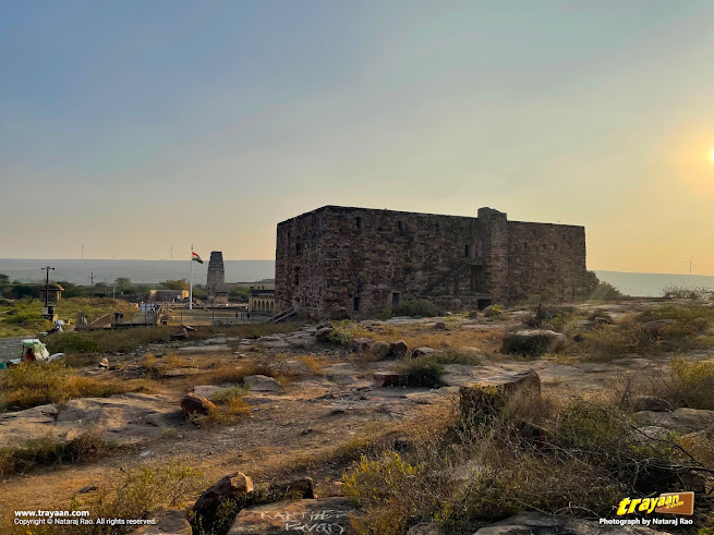
Other impressive monuments here is the Pigeon Tower or the Mini Charminar which has three floors, which is from the time of the Golconda sultanate. An old jail building stands next to it.
Sunset at Gandikota Gorge view point
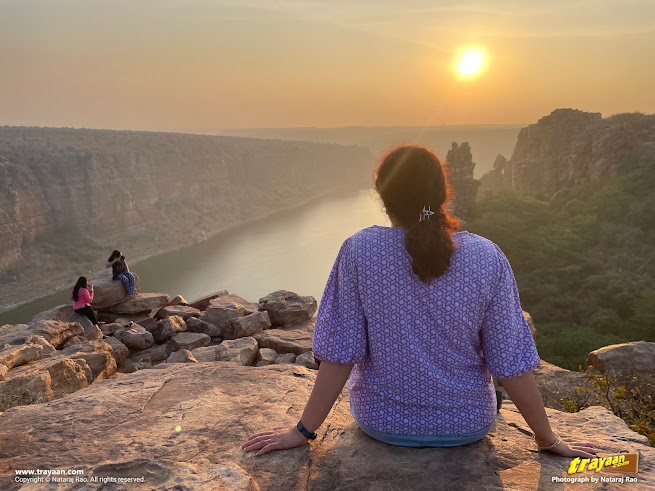
As the sun dipped below the horizon, I navigated towards the gorge, Gandikota's own Grand Canyon, using local guidance. The natural beauty and the breathtaking sunset over the canyon became the perfect conclusion to the day.

Day 2: The Spectacular Sunrise at Gandikota
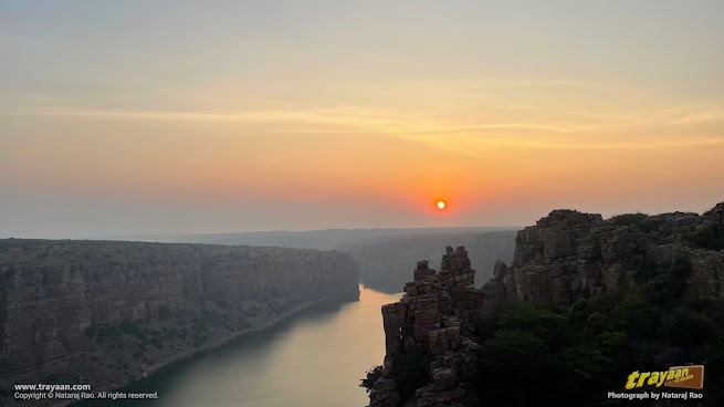
I ventured to the gorge for a sunrise spectacle. At around 6:00 AM, the grand canyon presented a delightful display of colours, and offered a splendid sunrise experience at this spectacular place. The soft morning light enhanced the beauty of the temples.
Apart from us, there were other tourists or travellers here, awaiting the sunrise in the early morning.
This was one morning very well-spent!
I bid my farewell to Gandikota, and my return journey to Bengaluru was filled with reflections of the historical marvels, spiritual experiences, and natural wonders that had enchanted me over the past couple of days.
Tourist Attractions in Gandikota
- Gandikota Fort: • Explore the ancient Gandikota Fort, known for its imposing structure and historical significance. The fort offers panoramic views of the surrounding landscape.
- Gandikota Gorge (Grand Canyon of the South): • Witness the breathtaking beauty of the gorge, resembling the Grand Canyon, especially during sunrise and sunset. The changing colours of the rocks and river offer a picturesque panorama.
- Pennar River Viewpoint: • Enjoy the serene surroundings and the gentle flow of the Pennar River from designated viewpoints.
- Shri Madhavaraya Swamy Temple and Shri Raghunatha Swamy Temple: • Discover the architectural marvels and spiritual tranquillity of the Shri Madhavaraya Temple and Raghunatha Swamy Temple, a Hindu temple that stands as a testament to the region's rich history.
- Jama Masjid and Pigeon Tower / Mini Char Minar: • Experience the cultural diversity of Gandikota by visiting the Jama Masjid, a historic mosque that adds to the architectural mosaic of the region.
As I returned to Bangalore by night, the memories of this enchanting expedition became a testament to the harmonious blend of the ancient and the contemporary, enriched by the diverse attractions that Gandikota has to offer.
Location Map of Gandikota
Tips for travellers
- The fort gives you a picturesquely panoramic view of the surrounding greenery and valleys here.
- There are many view points here. Some can be located in the location map.
- Be careful while going over the rocks.
- Mornings and evenings are great times for great views of the river and the gorge.
- And do not litter! There was litter around the viewpoints. Be more responsible and avoid littering. It is the traveller/tourist's responsibility to not dirty the places we visit.
Nearby Attractions
- Mylavaram Dam which lies nearby is a popular picnic spot which offers beautiful views and fresh breeze. It has boating services in the dam's waters as well as a park on other side. (See above Map by zooming in/out)
- Shri Agastheswara Kona temple and waterfalls on the opposite side of River Pennar from Gandikota. (See above Map by zooming in/out).
- Gandikota Reservoir offers great views of backwaters of Gandikota dam. (See above Map by zooming in/out)
- Belum Caves, the second largest natural caves in the Indian subcontinent, is around 62 Kilometres from Gandikota by road.
- Tadipatri, which has the beautiful historical Sri Chintala Venkataramana Swamy Temple, is around 78 kilometres from Gandikota via Jammalamadugu, and around 83 kilometres via an alternative route, both by road.
- Owk, a town with a dam and reservoir with boating, and nearby waterfalls, is around 76 kilometres from Gandikota by road. Owk is just around 16 kilometres from Belum Caves, by road.
Food & Accommodation
There is Andhra Pradesh Tourism Department's Haritha Resort and restaurant here, very close to Gandikota Fort and view points. It has many cottages, air-conditioned rooms, a dormitory, dining hall, and good parking space for your vehicle. This is where we stayed. There are also other accommodations and eateries here.
Best times to visit
The best times to visit, would of course, be during the winter or between between September to February, unless you can bear the summer heat here.
Also See in this Series
• Belum Caves — the second largest natural caves in the Indian subcontinent
Footnotes
- The anglicised name “Cuddapah” has renamed as “Kadapa” by the Government of Andhra Pradesh in 19th August 2005. It was later renamed as Y.S.R. District in the year 2010. [11]
References
- Gandikota - Rural Tourism, Ministry of Tourism, Govt. of India. Retrieved on 24 February 2024.
- ECO Tourism - District YSR(Kadapa), Government of Andhra Pradesh, India. Retrieved 24 February 2024.
- Gandikota - District YSR(Kadapa), Government of Andhra Pradesh, India. Retrieved 24 February 2024.
- Temples of Tadpatri - by N.S. Ramaswami, in Archaeological series No. 45. Page 10, 12. Published by The Government of Andhra Pradesh, Hyderabad, 1976.
- Temples of Cuddapah District. by Aenuganti Gurumurthi (1990). "The Mādhavarāya Temple". New Era. pp. 85–89. ISBN 9789991648798.
- Pictorial Atlas of Cuddapah basin. By Bhattacharjee, Santanu & Sai, V. & Tripathy, Vikash. (2020). December 2020. Publisher: Geological Survey of India.
- Petrology, geochemistry and tectonic settings of the mafic dikes and sills associated with the evolution of the Proterozoic Cuddapah Basin of south India, by Chatterjee, N., Bhattacharji, S. J Earth Syst Sci 110, 433–453 (2001). https://doi.org/10.1007/BF02702905
- Quartzite - Geology - rocks and minerals. The University of Auckland. Retrieved on 24 February 2024.
- Shale - GeoKansas - Kansas Geological Survey, University of Kansas. Retrieved on 24 February 2024.
- Raghunatha Swamy Temple - Nidhi - National Integrated Database of Hospitality Industry, Ministry of Tourism, Govt. of India. Retrieved 24 February 2024.
- History - District YSR (Kadapa), Government of Andhra Pradesh, India. Retrieved 24 February 2024.

